

CARACAS, VENEZUELA.- The Venezuelan authorities have alerted the population through the competent organizations such as Civil Defense and INAMEH, the latter being the meteorology institute, before the arrival of a possible tropical cyclone that at this time of writing this note would be touching the coasts of the east of the country crossing the island of Trinidad and Tobago including the lesser Antilles.
The entity in charge indicated that there is a 90% chance that the tropical wave that is being monitored, since the weekend, will become a storm.
The National Institute of Meteorology and Hydrology (Inameh) and the National Organization for Rescue and Maritime Safety of Aquatic Spaces of Venezuela (ONSA Venezuela) reported, through bulletins, that a tropical wave is approaching the country with a high probability of becoming a tropical depression .
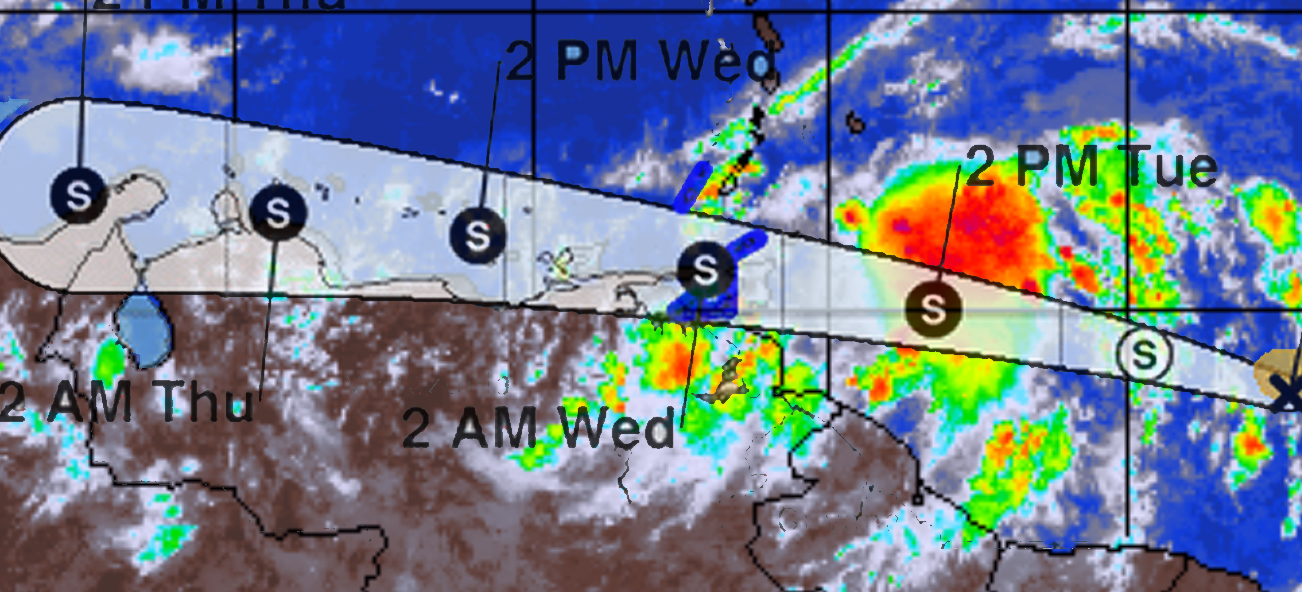
The meteorological services estimate that it will hit Nueva Esparta and Sucre between the afternoon of Tuesday the 28th and the early hours of Wednesday the 29th; meanwhile, Inameh and ONSA keep their systems on alert before tropical wave number 12. It is not ruled out that the entire north-coastal axis will be affected by the phenomenon
According to reports from Inameh on Sunday the 26th and this Monday the 27th, tropical wave number 12 is expected to affect the northeastern region of Venezuela in the next 72 hours. This cloudy formation moves at about 27 kilometers per hour and is already located near the east of the country, specifically in the state of Sucre.
After hearing the report, the Minister of Internal Affairs, Justice and Peace, Remigio Ceballos Ichaso, urged the population to take measures in order to guarantee “comprehensive prevention for life and peace.”
The meteorologist Luis Vargas indicated, through his account on the Twitter social network, that the wave with a cyclonic perspective is very close to the country.
“According to the projection of the NHC, the system (PCT02) would reach the east of Sucre state on Wednesday morning and during the morning it would pass north of Nueva Esparta. It will continue to be very close to our coasts and early Thursday morning it would be in the Paraguaná peninsula,” he said.
The report indicates that this week tropical waves 11 and 12 will affect Venezuela due to their interaction with the country’s intertropical convergence strip, which causes highly developed clouds with rain or showers, with the possibility of electrical activities in the north center. coastal, central plains, northeast, insular area, Amazonas and Bolívar.
Cloudy areas and scattered drizzles are expected in Zulia, the Andes and Apure.
On the other hand, ONSA issued a warning of “tropical disturbance” due to the tropical wave that is close to the country for the northeastern, Central Plains, western, North-Coastal Axis, Falcón and Zulia areas, which will begin to affect them in the next 72 hours. .
ONSA predicts that the rains that will be recorded will be of a stormy nature, since they estimate that the tropical wave has the “potential” to become a tropical storm. If so, it would receive the name “Bonnie”.
The National Center for Disaster Prevention of Mexico (Cenapred) helps to establish the difference between what is a tropical depression, a tropical storm and a hurricane, where the speed at which they move is the main characteristic that makes them vary.
-
Tropical Depression: Its winds are less than 63 km/h.
-
Tropical storm: Registers winds of between 63 km/h to 118 km/h.
-
Hurricane: Presents winds with a speed greater than 118 km/h.